| Water Towers and Standpipes of the United States of America. Sponsored by "Understanding Your Home" by building inspector Mark Visser | |||||||||||||||||||||||||||||||||||||||||||||||||||||||||||||||
|
.....
|
||||||||||||||||||||||||||||||||||||||||||||||||||||||||||||||
|---|---|---|---|---|---|---|---|---|---|---|---|---|---|---|---|---|---|---|---|---|---|---|---|---|---|---|---|---|---|---|---|---|---|---|---|---|---|---|---|---|---|---|---|---|---|---|---|---|---|---|---|---|---|---|---|---|---|---|---|---|---|---|---|
.jpg) |
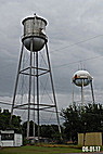
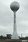
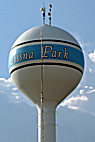
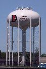
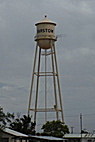
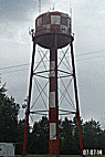
Tower Information -L Signage: Built: Height: Capacity: Tower Information - R Location: Route 17 at Gloucester School Bus garage Signage: Gloucester (Bus? Lines Built: Height: Capacity: Missing tower data: Please contact us if you have more information. |
.gif) |
|||||||||||||||||||||||||||||||||||||||||||||||||||||||||||||
Area Information History: The county would not be formed until 1651Gloucester's role during the American Revolution was a pivotal one. The southern tip of the Gloucester County peninsula extends into the York River and is directly across from Yorktown. This finger of land, named Tyndall's Point for Captain John Smith's mapmaker, Robert Tyndall, became known as Gloucester Point at the time of the Revolution. A fortification existed here already, built to protect the waterways of Virginia. The British Army refortified the point in August 1781, and British forces occupied the point for much of the War. Gloucester Point is the site of the "Second Surrender" by General Charles Lord Cornwallis to General George Washington at Yorktown. Many believe that the county was named for Henry, Duke of Gloucester, third son of Charles I. Others think the county was named for the County of Gloucester in England. Resources: Gloucester County History Other sites you may be interested in: Thumbnail Collection of USA Water Towers Canadian Water Towers and Standpipes Magnetic Hills in the United States of America The History of the Christian Fish Symbol |
|||||||||||||||||||||||||||||||||||||||||||||||||||||||||||||||
|
|||||||||||||||||||||||||||||||||||||||||||||||||||||||||||||||
| Home | Back to Virginia Index | ||||||||||||||||||||||||||||||||||||||||||||||||||||||||||||||


A.gif)